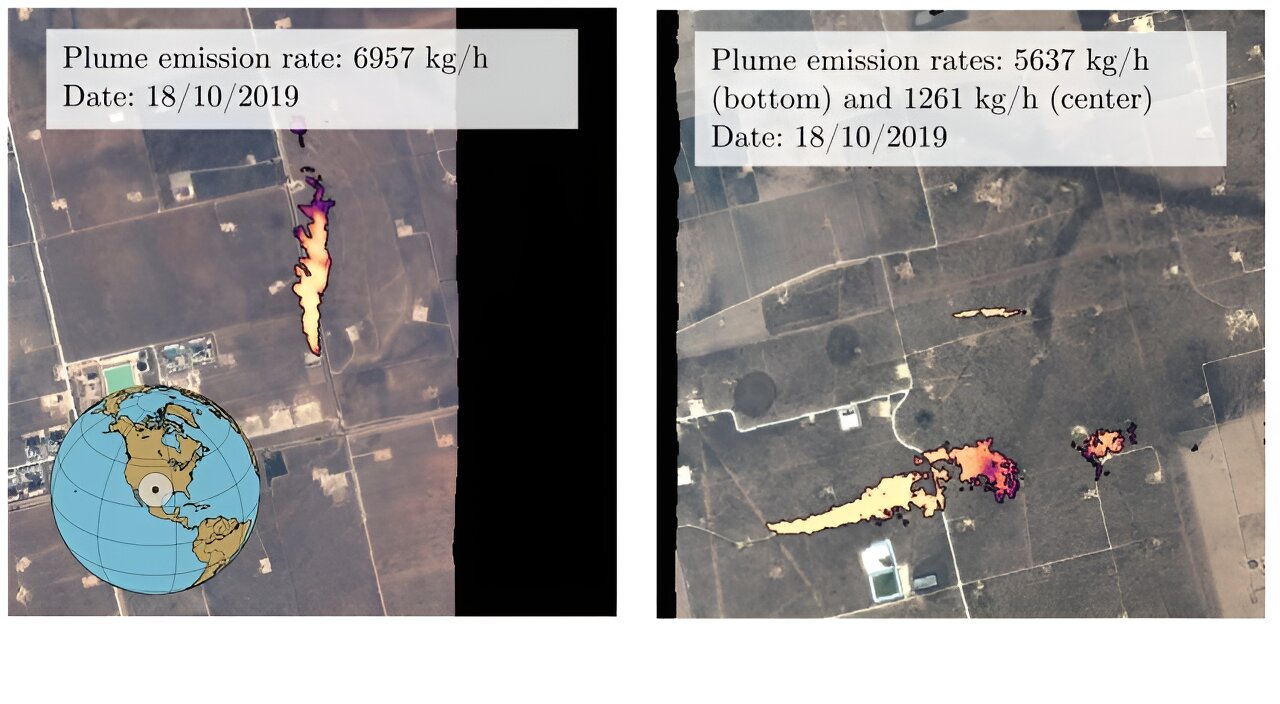
Based on data collected during the 2019 AVIRIS flying mission over the Four Corners region of the United States, predictions regarding methane leaks were formulated. A collaboration between the University of Oxford and Trillium Technologies’ NIO led to the development of a tool that utilizes system understanding and spectral information to swiftly identify gas plumes on Earth. This tool plays a crucial role in detecting significant gas emitters, thereby supporting more efficient strategies to minimize greenhouse gas emissions.
The research outcomes, detailed in the publication “Scientific Reports” titled “Semantic Segmentation of Methane Plumes with Hyperspectral Machine Learning Models,” underscore the significance of addressing gas emissions to mitigate the rise in temperatures. While the Net Zero target primarily concentrates on CO2 emissions, methane, due to its shorter atmospheric lifespan of about seven to 12 years in comparison to centuries for CO2, possesses significantly higher heat-trapping potency, being 80 times more effective. Hence, taking prompt measures to decrease methane emissions from human sources can yield immediate benefits in mitigating global warming and enhancing air quality. Projections indicate that attainable reductions in methane emissions over the next two decades could prevent nearly 0.3°C of warming.
Traditionally, the swift mapping of methane plumes from aerial images has been restricted, with the processing procedures being time-consuming. This challenge stems from satellite sensors capturing spectral ranges visible to both human vision and methane gas, often resulting in data obscured by noise and requiring labor-intensive manual methods for precise plume identification.
To overcome these constraints, Oxford researchers devised an innovative machine learning tool capable of identifying gas plumes in spectral satellite data. These tools are finely calibrated to the distinct gas signatures, effectively sieving out noise by detecting narrower spectral bands than traditional multispectral spacecraft. However, the surge in data volume poses processing challenges without the aid of artificial intelligence (AI).
The algorithm was utilized to analyze data from other hyperspectral sensors in orbit, incorporating data from NASA’s EMIT mission aboard the International Space Station, providing extensive Earth coverage. By training the model with 167,825 high-resolution tiles from AVIRIS data over the Four Corners region, the researchers achieved a noteworthy enhancement in accuracy compared to existing methods, with an overall detection reliability surpassing 81% for large biogas plumes. Furthermore, the algorithm notably reduced false positive classifications by roughly 41.83% compared to previous techniques.
The researchers have openly shared both the labeled data and the model code on GitHub to encourage further exploration in methane detection. They are evaluating the feasibility of deploying the model directly on satellites, enabling multiple satellites to carry out follow-up observations as part of the NIO initiative.
Lead researcher Vt. Rika, a DPhil scholar from the University of Oxford’s Department of Computer Science, envisions an alert system where identified methane sources trigger immediate alerts, streamlining coordinated satellite actions. This strategy could empower satellite constellations to autonomously adjust their imagers based on initial detection signals, enhancing the efficacy of methane detection endeavors.


