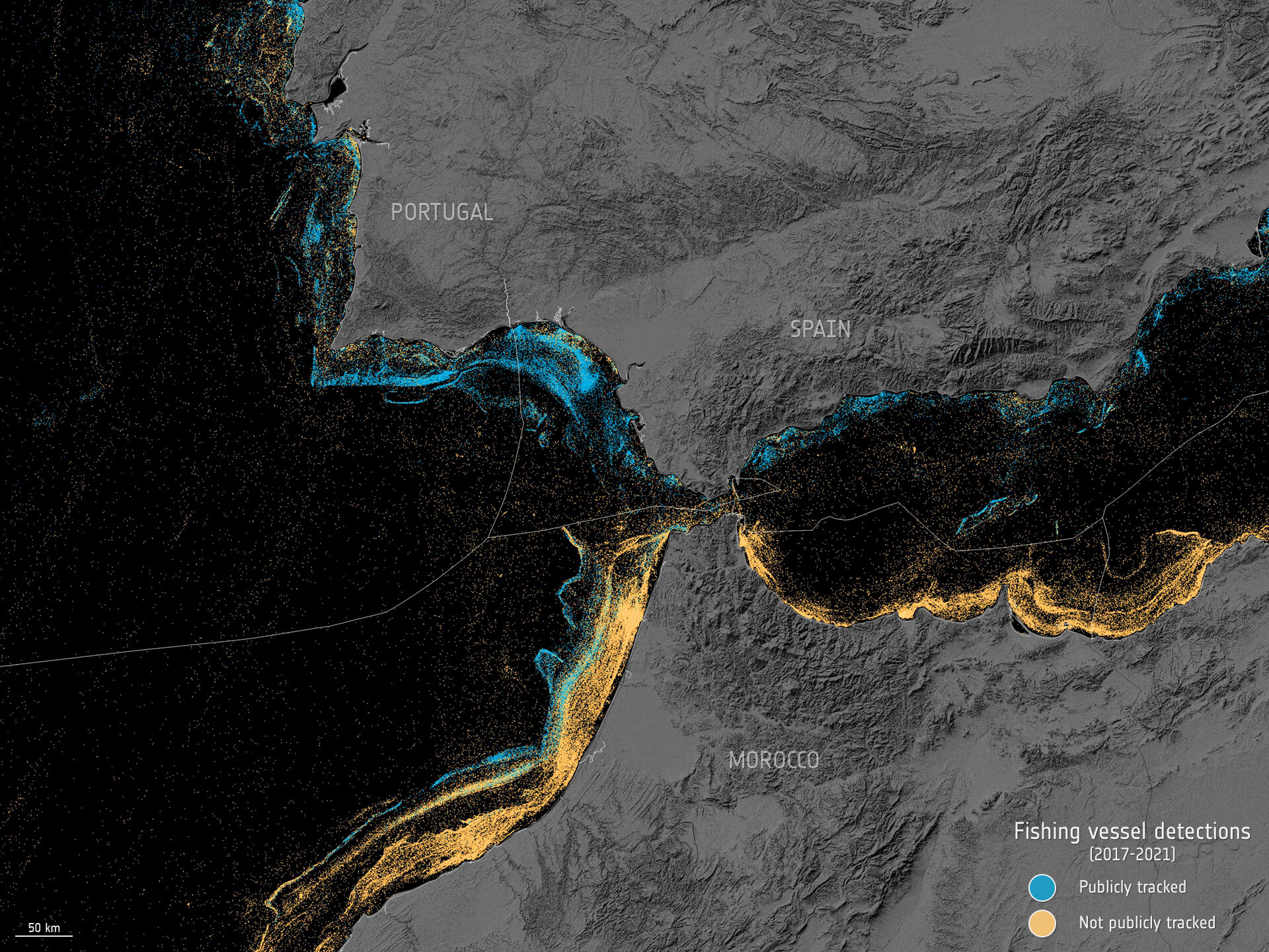
A pioneering research endeavor that merges satellite data with Artificial Intelligence has unveiled fresh insights into the presence of vessels at sea. Surprisingly, the study discloses that approximately 75% of the world’s industrial fishing vessels were previously undetectable by public tracking systems, existing in what is known as a ‘dark’ state.
Recently featured in the journal Nature, the study was spearheaded by Global Fishing Watch, an organization dedicated to advancing ocean governance by enhancing the transparency of human activities at sea.
While not all boats are mandated to broadcast their locations, vessels absent from public monitoring systems, often referred to as ‘dark fleets,’ can present challenges in safeguarding and managing natural resources.
Utilizing five years’ worth of radar data from the Copernicus Sentinel-1 mission, optical data from the Copernicus Sentinel-2 mission, and GPS information, researchers from Global Fishing Watch successfully pinpointed ships that had previously concealed their positions. By leveraging machine learning techniques on this data, the researchers were able to ascertain which vessels were involved in fishing activities.
The study period, spanning from 2017 to 2021, encompassed coastal waters across six continents, where the majority of fishing and offshore infrastructure activities are concentrated.
The investigation unveiled numerous dark fishing vessels within various marine protected areas, as well as a dense cluster of vessels in the waters of several countries that had previously shown minimal vessel activity according to public monitoring systems.
Moreover, it came to light that over 25% of transport and energy vessel operations were untraceable by tracking systems.
David Kroodsma, Director of Research and Innovation at Global Fishing Watch, remarked, “A new industrial revolution has been unfolding in our oceans unnoticed until now. While on land, we possess detailed maps of nearly every road and building globally, the growth in our oceans has largely remained concealed from public view. This study eliminates these blind spots and illuminates the extent and intensity of human activities at sea.”
Fernando Paolo, Senior Machine Learning Engineer at Global Fishing Watch, added, “Traditionally, vessel activities have been inadequately documented, limiting our comprehension of how the ocean, our planet’s largest public resource, is being utilized. By integrating space technology with cutting-edge machine learning, we have mapped undisclosed industrial activities at sea on an unprecedented scale.”
The publicly available data suggests a comparable number of fishing vessels in Asia and Europe within their respective borders. However, a closer examination reveals a stark contrast. Jennifer Raynor, Assistant Professor of Natural Resource Economics at the University of Wisconsin-Madison, noted, “Our mapping indicates a dominance of fishing vessels in Asia. For every 10 fishing vessels identified, seven were located in Asia compared to only one in Europe. The revelation of dark vessels has provided the most comprehensive public overview of global industrial fishing to date.”
The study’s findings not only have implications for identifying vessels engaged in illegal fishing but also contribute to a better understanding of greenhouse gas emissions at sea.
In addition to its impact on targeting potentially illicit fishing activities, these findings offer valuable insights into the emissions of greenhouse gases at sea.
Offshore Infrastructure
The study also delved into offshore infrastructure such as wind turbines and oil platforms. Over the study period, there was a 16% increase in oil structures and a more than twofold rise in wind turbines. By 2021, the number of turbines surpassed that of oil platforms, with China’s offshore wind energy sector experiencing remarkable growth, expanding ninefold between 2017 and 2021. This analysis is crucial for comprehending development impacts and trends in this sector.
Global Vessel Detections


