Every night, an increasing volume of plastic waste finds its way into the waters. Utilizing satellite imagery, researchers can locate and eliminate the waste that accumulates along shorelines and in bodies of water. Despite cloud cover or adverse weather conditions, a research team has developed an enhanced artificial intelligence system capable of detecting floating plastics in satellite images more efficiently than ever before.
The prevalence of inexpensive goods in our society is expected to lead to a rise in cheap waste production in the future. Improper disposal or lack of recycling often results in the accumulation of waste in rivers and lakes, eventually making its way into the oceans, where it can amalgamate with algae and driftwood to form marine debris clusters.
Recently featured in iScience, a study by scientists from Wageningen University and EPFL introduces an AI-powered sensor that assesses the probability of coastal debris visibility in satellite images. This innovation, when paired with boats, could facilitate the systematic removal of plastic waste from the sea.
Leveraging AI for Analyzing Satellite Imagery
Sentinel-2 satellite images, capturing maritime areas worldwide every 2–5 days, reveal concentrations of marine debris on land masses and coastal regions. Analyzing these vast amounts of data requires the swift application of artificial intelligence techniques like deep neural networks.
These models are trained using examples provided by oceanographers and remote sensing experts who have visually identified numerous instances of marine debris in satellite images from various locations globally, as explained by Marc Rußwurm, an associate professor at Wageningen University. By “training” the model in this manner, they have enabled it to detect marine debris effectively.
Enhanced Detection in Challenging Conditions
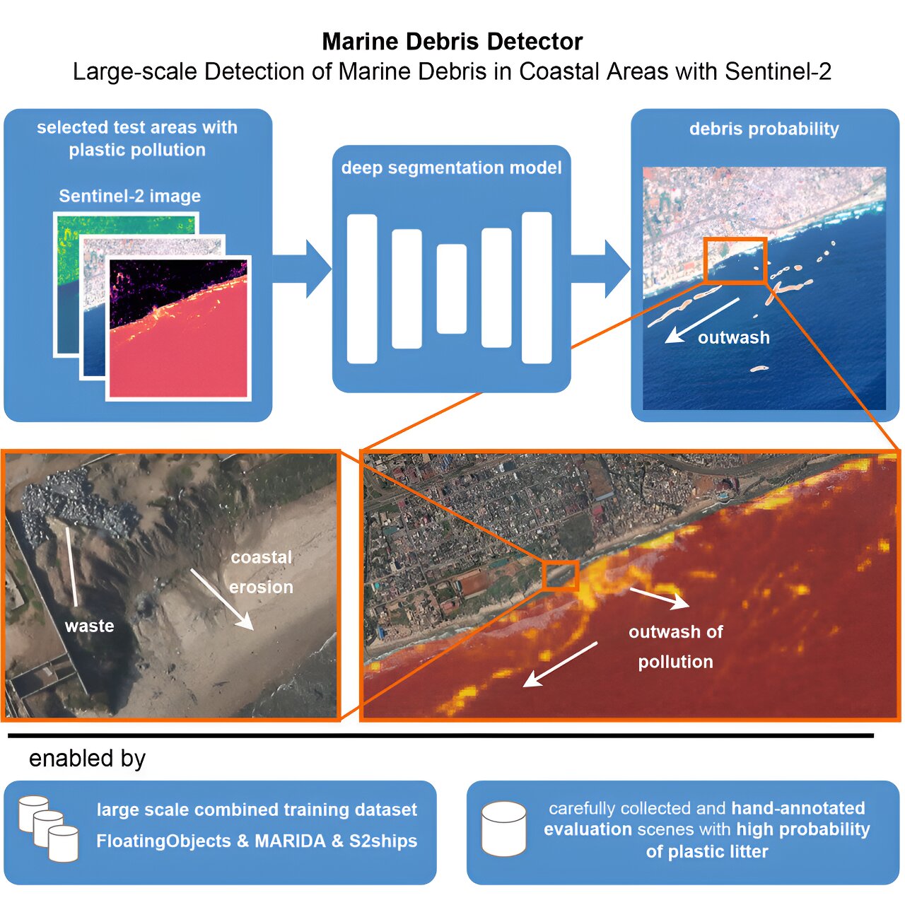
To predict the presence of marine debris in each pixel of Sentinel-2 satellite images, the researchers developed an AI-based marine debris detector. This sensor follows data-centric AI principles to maximize the utilization of limited training data available for addressing this issue.
For instance, a computer vision algorithm accurately annotates visible debris in images based on expert input. This tool allows oceanographers and remote sensing specialists to provide additional training data examples by outlining debris less precisely manually.
Thanks to this training approach and refinement algorithm, the deep artificial intelligence detection model outperforms previous methods in accurately anticipating marine debris objects, even under challenging conditions. According to Rußwurm, the detector maintains its accuracy in scenarios where existing models struggle to identify marine debris due to cloud cover and atmospheric interference.
 Sentinel-2 image featuring expert annotations of marine debris depicting plastic waste in the Indian Ocean. Credit: ESA
 Plastic waste in Durban Harbour. Credit: Ash Erasmus
Tracking Plastic Waste Post-2019 Easter Floods in Durban
Given that plastics are often carried into water bodies following heavy rains and storms, it is crucial to detect them within marine particles under adverse atmospheric conditions like clouds and haze. The 2019 Easter floods in Durban, South Africa serve as a case in point: Extensive rainfall led to overflowing rivers, resulting in a higher-than-usual amount of debris being washed away.
This debris made its way into the Indian Ocean via the Durban port. Such items, floating amidst the water, are challenging to discern in satellite images using conventional color channels. By leveraging alternative spectral programs such as near-infrared light, these objects become visible.
Insights from Dual Monitoring of Debris Movement
In addition to improving the accuracy of coastal debris aggregation predictions, the diagnostic model can identify debris in daily PlanetScope images. Combining regular Sentinel-2 and PlanetScope acquisitions can pave the way for continuous monitoring.
Rußwurm highlights, “The simultaneous capture of the same marine debris area by Sentinel-2 and PlanetScope, albeit minutes apart, reveals the effects of wind and ocean currents on water movement.” This dual monitoring approach can enhance models for estimating marine debris drift patterns.